Specific Prior Term
Although the result obtained at full resolution using the multi-scale data term is an improvement over the result obtained using the single-scale data term, it is still unsatisfactory. It indicates that a simple sum of data energies at several different scales, while helpful, cannot solve the problem completely, and suggests that stronger prior knowledge is more prominent.
The prior energy EP in [1] is generic: it incorporates constraints in the form of network regions that are true of any network. To improve further the results at full resolution, we introduce a specific prior energy, based on a GIS map. The map was obtained a few years earlier than the satellite images, and thus represents a slightly different road network. In our preliminary test on Fig. 2(a), we actually use a 'simulated' map (Fig. 2(b)) instead of the original GIS map, because the road network in this piece of image is not very different from the GIS map. The additional specific prior energy measures the difference between the road areas in the map and those given by our segmentation. Its effect is to reduce significantly false detections in the background, as displayed in Fig. 2(c). In order to free the method from the need for a GIS map, we replace the GIS map by the result obtained at a lower resolution without the GIS map. The results show little change. It means that a GIS map, although useful, is not necessary.
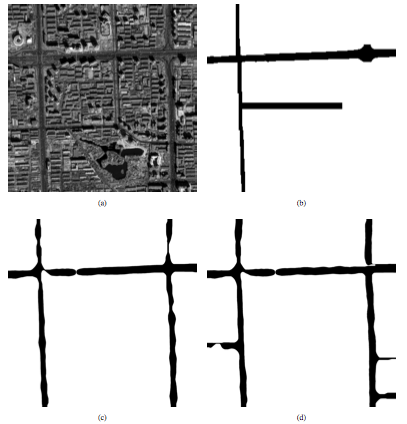
Fig. 2 Experiments at full resolution
using the specific prior term. (a) a QuickBird image (size:
2560 × 2560); (b) deliberately 'damaged' ground truth, to
simulate an earlier GIS data; (c) result obtained with
'damaged' ground truth (Fig. 2(b)); (d) result obtained
using the result obtained at 1/8 resolution without a GIS
map as a replacement for the GIS information.
Two further experiments are illustrated in Figs. 3 and 4.
The images acquired in the year 2006 (Figs. 3(b) and 4(b))
are used as inputs. The original GIS maps of the main road
networks for the same zones before the year 2002 (Figs.
3(c) and 4(c)) are used as the specific prior. Great
changes exist between the maps and the new satellite
images. The results obtained with the new specific prior
term are presented in Figs. 3(d) and 4(d). These
experiments show that for the main roads, at full
resolution, this model is able to keep the unchanged roads,
to correct the mistakes, and to extract new roads.
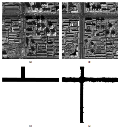
Fig. 3 Experiments at full resolution
using the specific prior term. (a)-(b): a pair of QuickBird
images (size: 1000 × 1000), left: year 2002, right: year
2006; (c) GIS map of the main road networks before the year
2002, used as the specific prior; (d) the main road
networks updated using the QuickBird image from 2006.

Fig. 4 Experiments at full resolution
using the specific prior term. (a)-(b): a pair of QuickBird
images (size: 1000 × 1000), left: year 2002, right: year
2006; (c) GIS map of the main road networks before the year
2002, used as the specific prior; (d) the main road
networks updated using the QuickBird image from 2006.
Last update: Dec. 10, 2008